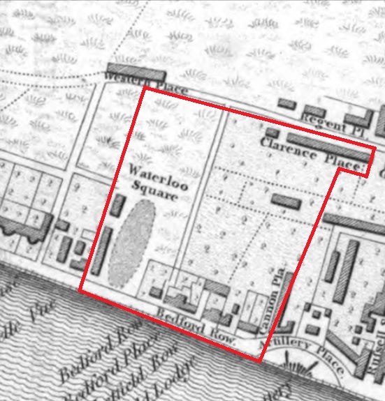
So, this is what the RSAS area looked like in 1822. In the north of the area was Clarence Place – the present north side of Clarence Square. At the far right-hand side of Clarence Place is the Prince of Wales pub, first licenced in 1864.
On the left of our area are the first buildings to be built on the west side of Regency Square. The RSAS publication “Regency Square, its history and its stories” explains how the error of marking it as Waterloo Square came about.
Cannon Place was built up on one side only. Ironically, it is only a few later buildings on the left hand side of the street that have survived, the rest having disappeared under the Churchill Square development in the 1960s.
Bedford Row, from left to right, shows what were then Nos 127 to 106 Kings Road. Most of these houses were swept away for the magnificent pile that was the Metropole – itself since seriously disfigured by developers.
Tucked behind Bedford Place was Westfield House, home, amongst others, to Charlotte Elliott (1789-1871) who wrote hymns and, William Cattlin (1814-1886) who bought up all or nearly all the plots of land on which the Metropole Hotel now stands. Just outside our area, the Grand Hotel ow dominates what was Artillery Place.
Preston Street has not yet been constructed and Cannon Place peters out before it reaches the first few houses that would later form Russell Square. For the rest, it was cliff-top grassland.
The Society would not have had many members in its area in those days.
Map: “Plan of Brighton Including the new improvements, 1822, published by Wetton and Jarvis (London)” See http://www.brightonhistory.org.uk/maps/index.html